Context:
- Delhi’s Indira Gandhi International Airport (IGIA), one of the busiest in Asia, recently faced serious operational disruptions due to GPS spoofing incidents. These incidents caused several flight diversions, go-arounds, and congestion, especially during the ongoing upgrade of the airport’s primary Instrument Landing System (ILS) on Runway 10/28.
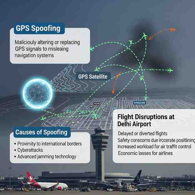
What Is GPS Spoofing?
GPS spoofing is a form of electronic interference where fake GPS signals are transmitted to mislead navigation systems.
In aviation, spoofed GPS signals can mislead aircraft navigation computers, potentially causing incorrect flight paths, false approach guidance, or system warnings.
Why Delhi Airport Was Affected
-
Runway Configuration: During easterly wind conditions, aircraft land from the Dwarka side and depart toward Vasant Kunj , increasing air traffic density.
-
ILS Upgrade: The main runway (10/28) was under Category III ILS upgradation, making pilots rely more on RNP (Required Navigation Performance) approaches, which depend heavily on GPS signals.
-
Spoofing Range: False GPS signals were detected up to 60 nautical miles from IGIA, causing navigation errors during approach and leading to diversions, mainly to Jaipur and other nearby airports.
Impact on Operations
-
Temporary suspension or invalidation of RNP approaches.
-
Increased go-arounds and diversions.
-
Heavy congestion and cascading delays across the network.
-
Reduced landing capacity during peak hours.
With IGIA handling nearly 1,550 flights daily , even brief signal disruptions can create large-scale delays.
About ILS and RNP Systems
Month: Current Affairs - November 06, 2025
Category: Science & Technology