The NASA-ISRO mission known as the Synthetic Aperture Radar (NISAR) has reached a significant milestone upon releasing the first pictures of the earth. These initial observations will be a milestone towards full-scale science activities later in the year 2025 when the satellite will be ready. It is anticipated that the data would greatly enhance disaster preparedness, agricultural surveillance, and infrastructure management throughout the world.
Mission Overview
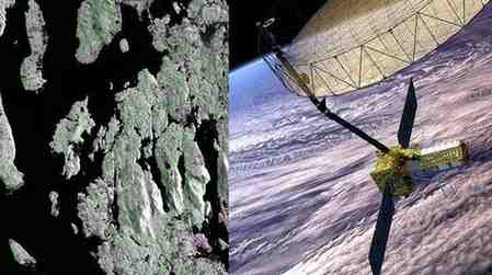
NISAR is an Earth observation project, which is a collaboration between NASA and the Indian Space Research Organisation (ISRO). The satellite, which has state-of-the-art L-band synthetic aperture radar (SAR) technology, was launched on 30 July 2025. In contrast to the conventional image system, SAR is able to produce high-resolution images of the surface of the earth during any weather and at any time of the day. This guarantees 24-hour surveillance of the environment and human activities.
Original Pictures and Major Impressions.
Some of the initial targets included Mount Desert Island, Maine and farmlands, North Dakota, northeastern. The radar images showed dramatic information of water bodies, forests, farmlands, wetlands and city infrastructure. The imagery provides a very detailed picture of the land use patterns and irrigation systems with the ability to differentiate objects as small as five metres.
Technology Behind the Mission.
The L-band radar by NISAR can cut through the clouds and plants such that it continues to see the landscape of the land that is mostly clouded in the optical imagery. It is capable of distinguishing tree cover, low vegetation, bare land and built-up environments with accuracy. It is a potent instrument to examine the ecosystems and the effects of human activity.
Ecological and Field Applications.
The data of the mission will be crucial in the tracking of forest cover, monitoring wetlands, and the cycles of crop growth. It will also assist in the evaluation of climate change effects and sustainable planning of land use. Governments and agencies may use these lessons to better respond to disasters, especially in case of floods, landslides, or earthquakes.
A Global Working Model.
NISAR is an effective collaborative effort between India and the United States involving NASA and the ISRO which has merged NASA radar technology with the proven success of ISRO launch efforts. In addition to Earth observation, the mission enhances collaboration in space science, and it may be used to inform future exploration of the Moon and Mars.
Month: Current Affairs - Sep 30, 2025
Category: current affairs daily