| Category |
Details |
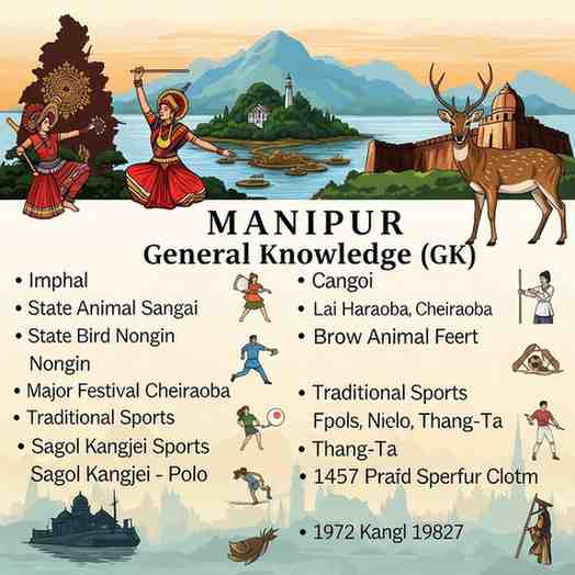
| Capital |
Imphal |
| Statehood |
21 January 1972 (Became a full state) |
| Chief Minister |
N. Biren Singh |
| Governor |
Najma Heptulla |
| Official Language |
Manipuri |
| State Animal |
Sangai (Brow-antlered deer) |
| State Bird |
Mrs. Hume's Pheasant |
| State Flower |
Shirui Lily |
| State Tree |
Toon / Indian Mahogany |
| Geographical Highlight |
Loktak Lake - largest freshwater lake in Northeast India |
| Unique National Park |
Keibul Lamjao - the world's only floating national park |
🗺️ Geography and Borders
Manipur is nestled in the northeastern part of India and is often described as a 'Little Paradise on Earth'.
-
Location : It is bordered by the Indian states of Nagaland to the north, Assam to the west, and Mizoram to the south. To the east, it shares an international border with Myanmar .
-
Topography : The state features lush hills surrounding a central valley. The Imphal Valley is the most densely populated and agriculturally productive region.
-
Major River : The Barak River is the main watercourse in the state.
-
Important Locations :
-
Loktak Lake : The largest freshwater lake in northeastern India, known for its floating phumdis (mass of vegetation).
-
Moreh : A key border town that serves as a major trade route between India and Myanmar.
📜 History and Polity
Manipur has a rich historical saga dating back to ancient times.
-
Ancient Kingdom : The kingdom of Manipur was established by Pakhangba in 33 AD. It is also mentioned in the epic Mahabharata through the story of Arjuna and Princess Chitrangada.
-
Colonial Era : The British ruled the state after defeating the Manipuri forces in the Battle of Khongjom in 1891.
-
Modern History : Manipur merged with the Indian Union on October 15, 1949 . It first became a Union Territory in 1956 and was granted full statehood on January 21, 1972 .
-
Administration : The state has a 60-member Legislative Assembly . It sends two members to the Lok Sabha and one to the Rajya Sabha.
🎭 Culture and Economy
Manipur's culture is a captivating blend of tradition and modernity.
-
Classical Dance : Manipuri Dance (also known as Jagoi ) is a renowned classical dance form, with Raas Leela depicting the divine love of Radha and Krishna.
-
Festivals : Major festivals include Yaoshang (Holi), Lai Haraoba (a spring festival for peace and prosperity), Ningol Chakkouba , and the Kut festival .
-
Economy : The economy is primarily agrarian , supporting two-thirds of its population. Key industries include handlooms and handicrafts , which are the largest cottage industries. The state is also one of India's largest producers of bamboo .
🐅 Forests and Wildlife
Manipur is rich in biodiversity, with significant areas under forest cover.
-
Keibul Lamjao National Park : This is the world's only floating national park , located on Loktak Lake. It is the last natural habitat of the endangered Sangai deer.
-
Other Protected Areas : The state also has Sirohi National Park and wildlife sanctuaries like Yangoupokpi Lokchao .
Month: Current Affairs - Nov 03, 2025
Category: