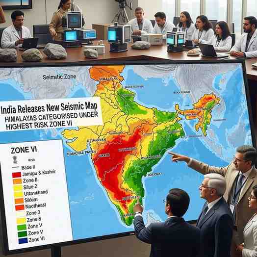
India Unveils New Seismic Map Placing Himalayas in Highest-Risk Zone VI
India has rolled out a revised national seismic map under the updated Earthquake Design Code, introducing a new Zone VI —the highest hazard category—and placing the entire Himalayan belt within it. This marks one of the most significant updates in India’s earthquake risk assessment, increasing the share of land classified as moderate to high hazard to 61% . The new framework is expected to reshape infrastructure planning, building practices and disaster preparedness across many vulnerable regions.
Uniform High-Risk Classification for the Himalayan Arc
The updated zonation eliminates inconsistencies between previous Zones IV and V, offering a more scientific representation of the seismic threat. Researchers have long warned that the central Himalayan segment holds accumulated strain from locked faults that have not released major energy for nearly 200 years. The reclassification reflects new insights into rupture behaviour and stress buildup along the Himalayan Frontal Thrust , one of the world’s most active tectonic boundaries.
Scientific Foundation of the New Map
The Bureau of Indian Standards employed probabilistic seismic hazard assessment (PSHA) techniques to develop the new model. These incorporate active fault data, maximum expected magnitudes, ground-shaking attenuation, subsurface geology and regional tectonics. Unlike earlier maps based largely on past earthquakes, the updated version provides a forward-looking risk estimate. Importantly, any settlement lying near a zone boundary must adopt the higher hazard category for safety.
Key Reforms in the 2025 Earthquake Design Code
New norms require heavy non-structural elements exceeding 1% of building weight to be braced to prevent internal failures. Structures near active faults must account for intense near-fault shaking, while guidelines on liquefaction, soil response and structural resilience have been strengthened. Critical facilities—hospitals, bridges, pipelines and schools—must remain operational after strong earthquakes.
Exam Oriented Facts
-
Entire Himalayan arc placed under Zone VI (highest hazard).
-
India’s moderate-to-high seismic risk area expanded to 61% .
-
New map created using PSHA methods.
-
Non-structural elements over 1% of building weight must be anchored.
Month: Current Affairs - December 02, 2025
Category: seismic hazard mapping, BIS code updates